BEIJING, July 12 (Xinhua) According to the website of the Central Meteorological Observatory, it is expected that a new round of heavy precipitation will occur from west to east in the eastern part of southwest China, western South China, north-central Jiangnan and southern Jianghuai from July 12. The Central Meteorological Observatory upgraded and issued a yellow rainstorm warning at 06: 00 on July 12.
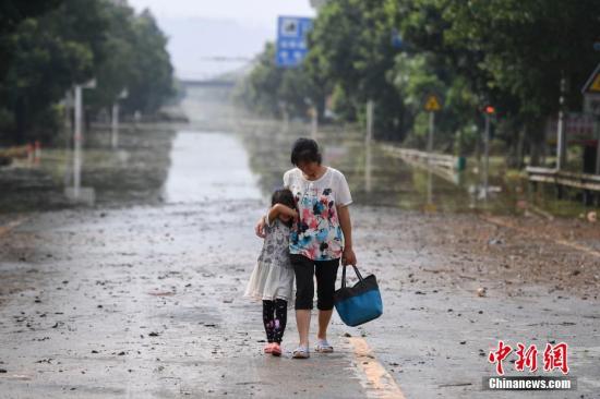
In the past few days, there has been continuous heavy rainfall in Hengdong County, which has caused widespread disasters in 17 townships, 233 villages and 22 communities in the county. The picture shows two villagers returning home on Dong Jian Avenue. (Profile picture) Photo by Yang Huafeng
The southern region will welcome a new round of heavy rainfall.
It is estimated that from July 12, a new round of heavy precipitation will occur from west to east in the eastern part of Southwest China, western South China, north-central Jiangnan and southern Jianghuai, among which, from 08: 00 on July 12 to 08: 00 on July 13, There are heavy rains in eastern and southern Guizhou, northwestern Guangxi, central and northeastern Hunan, southeastern Hubei, central and southern Anhui, southern Jiangsu, Shanghai, central and northern Jiangxi, western and northern Zhejiang, northwestern Fujian, southern Sichuan Plateau, western Yunnan and southeastern Tibet, among which there are heavy rains in northeastern Guangxi, southwestern and northeastern Hunan, southeastern Hubei, northwestern Jiangxi, southern Anhui and northwestern Zhejiang. Some of the above areas are accompanied by short-term heavy precipitation (the maximum hourly precipitation is 20 ~ 40 mm, and the local area can reach more than 50 mm), and there are strong convective weather such as thunderstorms and strong winds. The Central Meteorological Observatory upgraded and issued a yellow rainstorm warning at 06: 00 on July 12.
Thunderstorm weather in the northeast of Huanghuai, North China
In the next three days, there will be many showers or thunderstorms in North China, Huanghuai and Northeast China, and the rainfall will be unevenly distributed, accompanied by strong convective weather such as short-term heavy precipitation, thunderstorms or hail.
Specific forecast for the next three days
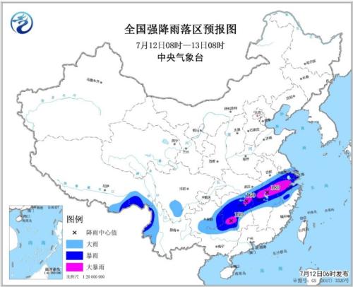
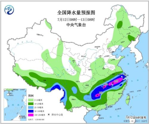
From 08: 00 on July 12 to 08: 00 on July 13, there were moderate to heavy rains in parts of southern and eastern Tibet, most of Jianghuai, eastern Jianghan, most of the south of the Yangtze River, southern Sichuan Plateau, southern Southwest China, northern and western South China, including southeastern Guizhou, northeastern Guangxi, eastern Hubei, central and western Hunan, northwestern Jiangxi, northern Zhejiang, southern Anhui, southern Jiangsu, Shanghai, western Yunnan and southeastern Tibet. There are 4 ~ 5 winds and above in parts of central Inner Mongolia and eastern Xinjiang.
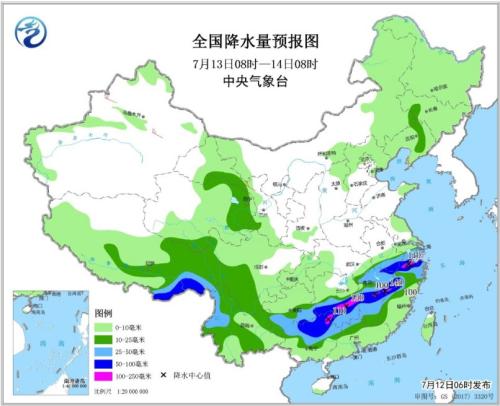
From 08: 00 on July 13th to 08: 00 on 14th, there were moderate to heavy rains in parts of southern and eastern Tibet, eastern Qinghai, southern Anhui, southern Jiangnan, southern Southwest, northern and western South China, among which there were heavy rains or heavy rains (100-150) in parts of southeastern Guizhou, northwestern Guangxi, central and southern Hunan, north-central Jiangxi, northwestern Fujian, southern Anhui, north-central Zhejiang and southeastern Tibet. There are 4 ~ 5 winds and above in parts of northern Xinjiang, central Gansu, Liaodong Peninsula and eastern Jiangnan.
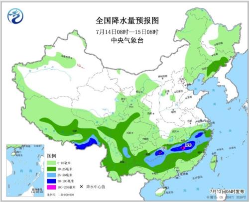
From 08: 00 on July 14th to 08: 00 on July 15th, there were moderate to heavy rains in parts of eastern Jilin, eastern Liaoning, eastern and southern Tibet, most of the south of the Yangtze River, southern southwest, northern and western South China, among which there were heavy rains or heavy rains (100-120 mm) in parts of eastern Guizhou, central and southern Hunan, central Jiangxi, central Zhejiang, northwestern Fujian and southeastern Tibet. There are 4 ~ 5 winds and above in parts of northern Xinjiang, central Gansu, Liaodong Peninsula and Shandong Peninsula.